PALOUSE BASIN AQUIFER SYSTEM
Hundreds of feet beneath the rolling hills of the Palouse, an aquifer system holds the drinking water for over 80,000 people. Groundwater has enabled communities stretching across Washington and Idaho to grow and thrive - from rural farmlands in Whitman and Latah counties, to cities like Pullman, Moscow, and Palouse, and into the college campuses of Washington State University and the University of Idaho.
Basin Boundary
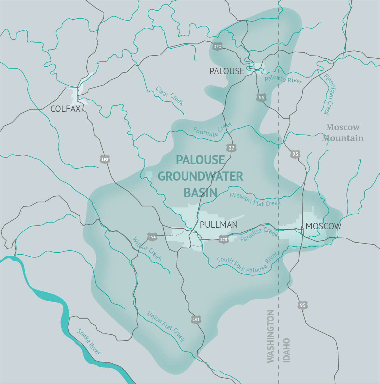
The Palouse Groundwater Basin is a geographic area that spans parts of eastern Washington and northern Idaho within Whitman and Latah counties as shown below. Find more details, including GIS files and a technical description of why the boundary was drawn where it is, under the Maps heading of the Information page.
Geologic Cross Section
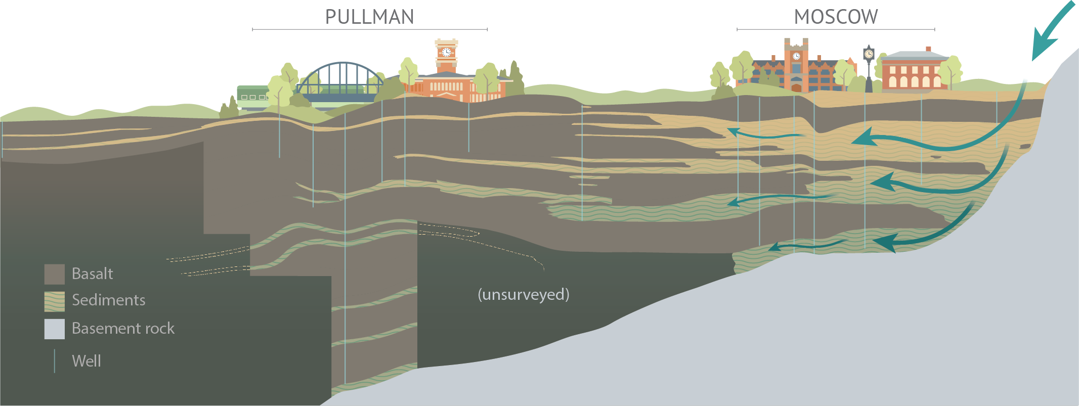
The Palouse Basin is made up of a complex, layered system of basalts and sediments. The sediments hold water within multiple aquifers formed millions of years ago. Impermeable rocks like granite prevent groundwater from escaping surround much of the eastern and southern portions of the basin.
There are two major aquifers in the basin which are referred to as the lower and upper aquifers. The connection between the upper and lower aquifer is considered to be minor. The water level separation between the two aquifers is generally greater than 100ft. Presently, lower aquifer wells are the only sources being used for municipal water in Pullman, Moscow, and Palouse, while most domestic wells drilled are typically located in the upper aquifer.
Find more details under the Information and Research pages.
Geologic Lecture Series
Want to learn more about the Palouse Basin? Watch the lecture series recorded by John H. Bush, Emeritus Professor of Geology, from the University of Idaho.
1. Introduction
2. Basin Boundaries
3. Origin of Miocene Aquifer Rocks
4. Basics of Columbia River Plateau Aquifers
5. Structural Features
6. Recharge
7. Upper Aquifer Characteristics
8. Conceptual Model of Moscow-Pullman Aquifer Systems
9. Geologic Controls on Water Level Decline & Model Testing
Water Cycle of the Basin
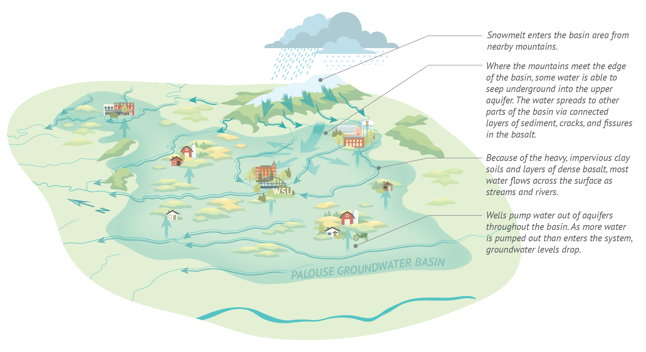
The Palouse Basin Aquifer System is a precious resource, and water levels have been steadily dropping since the communities were settled. More water is pumped out of the aquifer than enters it, and the geology of the basin makes it difficult for new water to replenish the aquifers. Understanding the geology of the basin helps to inform how water enters the aquifer system.
Water Usage & Declining Water Levels
In 2024, the region pumped 2.3 billion gallons of water.
This number is calculated from the water operators in the City of Pullman, Moscow, and Palouse, and Washington State University and University of Idaho. This does not include private residential well usage. Find the annual water usage reports on the Information page.
Water levels are presently declining at a rate of 0.7 feet per year.
In the 1990's decline was over 1 foot per year. The Groundwater Management Plan was enacted in 1992 and water levels have been consistently monitored since then. Find the annual water level hydrographs on the Information page.
Water usage has decreased per capita in the last 30 years, by 30% in Pullman/WSU and 43% in Moscow/UI. Conservation has helped decrease our region’s water use and slow the rate of water level decline, but it will not solve the problem completely. Current usage outpaces the system's ability to recharge. All wells in the basin draw from the same system - from the well that serves a single home to the municipal wells that serve thousands. It will take continued cooperation by all of us to ensure safe, reliable water for generations to come.


